Hadrian's Wall, Corvoran to Walton
I started the day's walk up a slope. There was no wall but just a massive ditch and earthwork.
I walked down into the ditch and even after more than 1,900 years, it was still deep and I couldn'r see out over the edge. Not a good photo but it gives an idea.
Some large fungi on a tree.
One of the ruined walls of Thirlmere Castle.
Thr next village was Gilsland. Overlooking the route are some new houses which have solar power and double glazing as standard which together with insulation should be the modern building code for all new builds rather than trying to retrofit them.
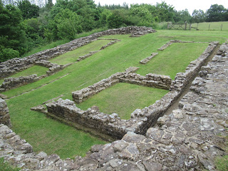
Gilsland is famous for its Popping Stone where Sir Walter Scotti popped the question to his future wife and less well known for its Pultross Burn Milecastle, a larger than average sized milecastle.
This is an artists impression...
...this was the reality...
...and another view from the opposite direction.
At Willowford the wall marches across the bottom of a valley and up the hill opposite but the path takes a short cut diagonally across a field to a kissing gate. Note the farmer on the red 4x4 quad bike.
I followed a sheep track, thinking that it was the track, looking for the gate but it was obscured by bushes. It was a big field and the sheep track continued through an open gate on a diagonal. I looked for the gate but saw none and only realised I was off track when I reached the far end and found no exit. And it was a very big field, more moor than carefully tended pasture.
I wasn't the only stray trekker, two girls that I had chatted to at the milecastle had followed me and I waved and shouted at them to turn back.
The farmer on the quad bike had come over and I apologised for walking on his land but he used to people going the wrong way and didn't exactly laugh but had a twinkle in his eye and said that the stile was three quarters of a mile back that way, pointing back the way I had just come and it had been uphill all the way, a serious issue when on foot for a log walk and carrying a day pack. It added time and distance to the schedule.
It was a Sunday and I had had a late start as breakfast was 8am, not the 7am I had expected. Also it was 40 minute drive from my accommodation to the start of the days walk and I had already made a navigation error, missing a sign, not on a post but nailed to a gate that you would not see walking forward as it was behind you.
One of the Willowford Turrets of which all along the wall, there are two between each milecastle.
This is a view of the wall as it dips towards the River Irthing, just behind the trees. The wall crossed the river on a three span arched stone bridge and three bridges had been built but washed away or demolished to be upgraded. Now there is a single, modern iron span to take walkers across the river and up the steep bank on the far side.
The day's walk, except for the start, had a large proportion of almost continuous stone wall running alongside of the trail and much of it at a reasonable height rather than just a few courses at ground level or overgrown but this is over two metres.
A picture of me to show the height of the wall.
The next major fort on the wall was Birdoswald, run by English Heritage. Entrance for a single adult was £11 and I had seen plenty of other stones set on other stones, some no higher than your knee.
I had already seen several ruins and glimpsing over the surrounding fences and through the gift shop windows, this seemed to be no different to the ruins that I had seen over the last few days. I am sure that it would be a great place to visit if it was your first or second ruin but I had seen a lot just recently. I walked on to Banks.
En route I came across an unusual stile and there were several on the route like this. It had stone steps up to about three quarters of the height of the wall and then a gap at the top of the wall protected by a little gate with a large metal spring to ensure that it always shuts after someone had passed through.
It is a steep walk down to the centre of Banks and an equally steep climb out of the village but on a good day, visiblr from here is the tower and ruins of the Lanercost priory, built with stone from the walls, just a few miles south and in the distance, the Pennines are visible and to the west, the viewer can make out the 12 storey, 44 metres tall civic centre in Carlisle and the 13th tallest building the UK to the west.
Between Banks and Walton are several long straight sections of wall and trail and the clouds had been blown away and it was a hot, sunny day making walking hard walk but if you are nt driving, there is always the Old Vicarage B&B and brewery for a lovely cooling pint!


No comments:
Post a Comment