Atherton Tablelands
At last I met Skippy on the way to breakfast. He hopped off to join his mates on a green field behind one of the buildings of the hotel. A couple of males were having a fight but I was too absorbed watching them and forgot to take a photo. Neither seemed to win, but they just stopped and went back to eating grass.
We drove up the road, crossed a river and started to climb into the Atherton Tablelands, a fertile plateau that forms part of the Great Dividing Range.
There were some great views from the coach as we climbed up and reached the high ground with views across the countryside.
It was largely farmland but some trees had been left.
Most of the farmed area was rolling countryside and so was used for grazing rather than for crops.
Another countryside scene.
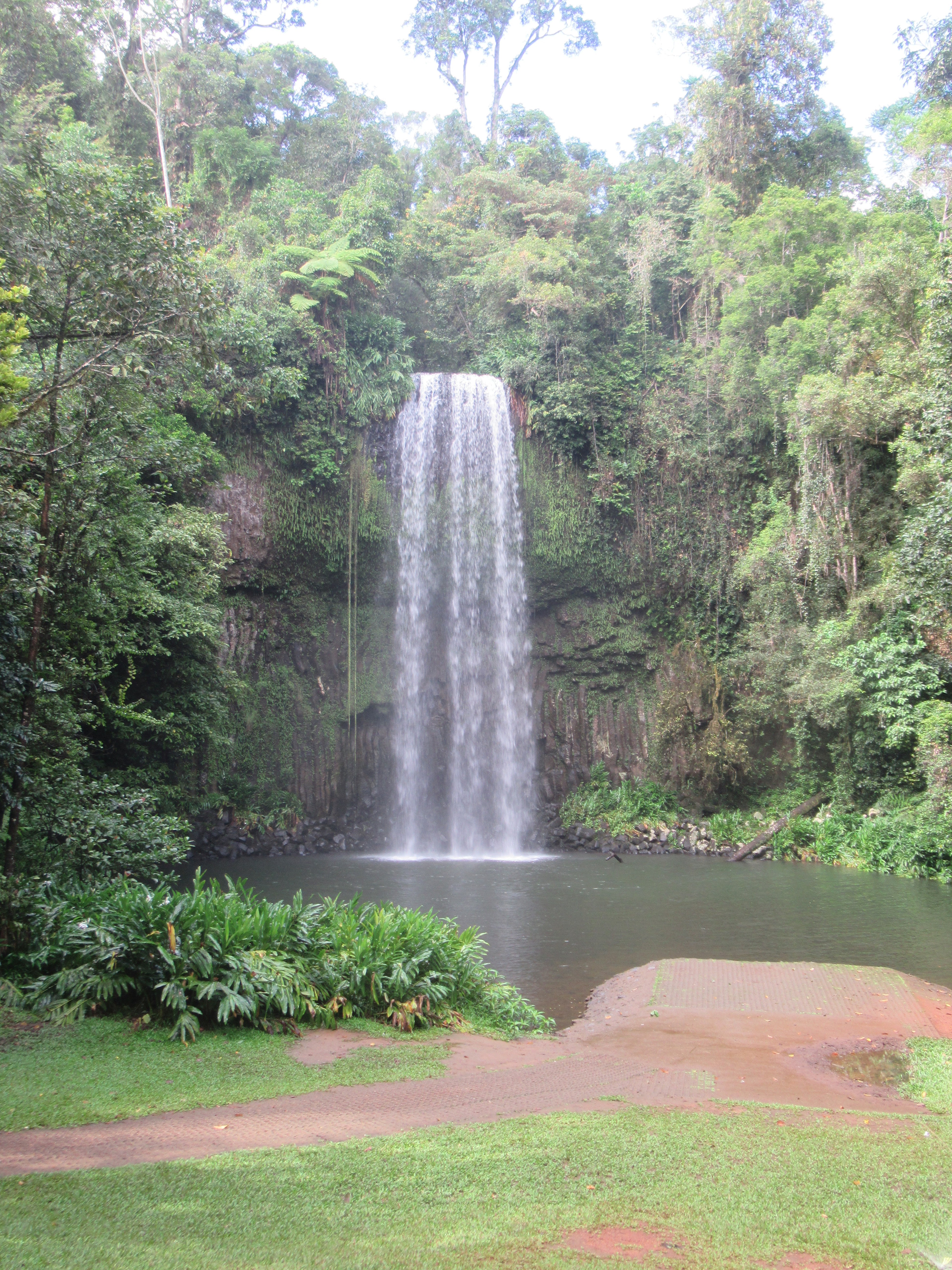
Plate tectonics caused several volcanoes to erupt in the area, covering the then existing topography in basalt, lava and ash with a high plateau. This area was subsequently eroded and several waterfalls were created on rivers that drain the plateau.
There is a Waterfall Circuit that encompasses ten of the best waterfalls in the area. It is a popular holiday destination as it is near and due to its elevation, people can escape the high temperatures of summer for cool mountains and swim in the rivers, plunge pools and lakes.
The Millaa Millaa Falls which are on the Waterfalls Circuit. They are very recognisable as they appear on many websites and have featured in several advertisements and films. It is also the place recorded on a memorial plaque where Christie Palmerston camped on one of his many journeys to discover new tracks and to discover gold.
It was a short trip from Millaa Millaa to Malinda where we were greeted with a large mural which shows everything that the area has to offer such as diary farming, platypus, waterfalls, an ancient aboriginal community, forestry and wildlife.
The War Memorial in Malinda. It always strikes me that these communities gave so much. It is only a small community but there are long lists of names remembered on the memorial and some are repeated which in a small community probably represents extended family losses. It is a memorial to those lost in the First and Second World Wars but they are two additional names added for later conflicts for local losses in Vietnam and Afghanistan.
In the same park is a plaque to commemorate the English family who were instrumental in creating this community. James and Catherine English settled here in 1907 and their nine children were prominent in various areas. They set up several farms and diary herds.
The English family also built multiple buildings in the town and surrounding area such as the Majestic Theatre.
And the local hotel...
...and above the door is the inscription that is is one of the buildings built by MG English and Sons in 1911.
There are plenty of other original time period era such as these two and...

...the post office.
The arrival of the railway in 1910 with the completion of the railway bridge across the river was a boost to the local economy and is remembered in a mosaic outside one of the buildings.
The mosaic.
The town has a modest park named after James May, situated on land that was originally occupied by the railway for the station, goods warehouses and shunting yards.
A plaque to the founder.
Inside the park is an art installation that repeats the mosaic theme...
...and a statue to commemorate the pioneer families who worked so hard to create their communities.

The plaque that commemorates those pioneering families.
Then it was a short drive to the Lake Eacham Crater Lakes National Park. The lake is fed by rain water but has no in or out flowing streams. It is up to 65 metres deep and has one freshwater crocodile living in it. You can swim in the lake but the freshwater crocodile is not considered dangerous as it is only small and timid so will swim away. But there are warning signs not to confront it or cut off its means of escape.
The fresh clear waters of the lake. It was formed when magma came into contact with ground water and superheated it so much that it blew through the surface and created a deep vent that filled with water.
There is a trail around the shores of the lake with information boards every few hundred metres. Many of the trees have buttresses, aerial roots and strangler vines. Here the path cuts through one of the web of strangler vines.
We stopped at Yungabarra for lunch. The old railway station.
Then it was five minutes down the road to the Curtain Fig National Park.
The strangling fig vine creeps up a parent parent tree and will eventually engulf it and kill it off. Here, the vine killed the parent tree but it collapsed against another tree The vine continued to send down shoots and had created a curtain around both the still upright tree and the original tree which toppled against it. Ultimately, the fig vine will soother the new upstanding tree but that will be several years away. It is a protected site but only until the vine kill the second tree
Then it was a steep and very winding descent off the plateau towards Cairns. The views were great to the naked eye but very difficult to catch on camera.
Looking back at the mountains after the descent from the plateau.
And then we headed along the main road into Cairns.


No comments:
Post a Comment